NWKRAFT probably sounds like gibberish to most people.
But it’s an important pilot acronym.
The NWKRAFT checklist is a memory aid that helps pilots recall necessary information for flight planning. It includes navigational, operational, and meteorological factors that pilots need to take into consideration.
Let’s explore it in more detail.
What Does NWKRAFT Stand for?
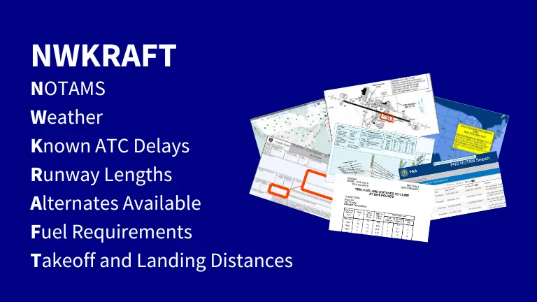
NWKRAFT is an acronym for NOTAMs, Weather, Known ATC delays, Runway lengths, Alternates available, Fuel requirements, and Takeoff and landing distances. NWKRAFT is a mnemonic used by pilots to remember crucial preflight action items (14 CFR 91.103), which are critical information that pilots should be familiar with before a flight.
NWKRAFT Explained Letter by Letter
You know what the letters stand for, but what’s their significance? Let’s go through them one by one.
NOTAMs
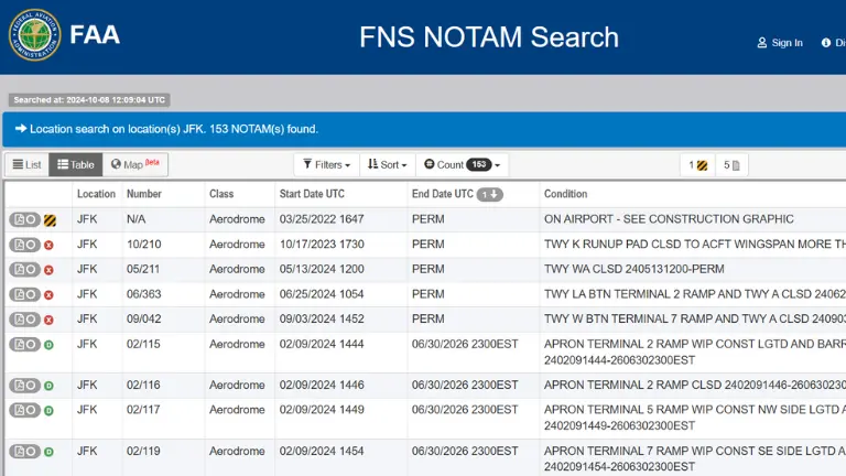
NOTAM is another aviation acronym for Notice to Airmen (now Notice to Air Missions in the US). Simply put, NOTAMS are notifications containing information that may affect or pose a hazard to an aircraft along a flight route (e.g., runway closure).
But how can you check the NOTAMs?
For general aviation pilots, you can access NOTAMs at an airport’s flight briefing facility, through an app like ForeFlight, or via a website such as the Federal NOTAM System (FNS) website in the US.
However, in an airline environment, companies provide pilots with NOTAMs relevant to their intended route. Flight dispatchers often prepare these NOTAMs in print or digital form during flight planning.
Weather
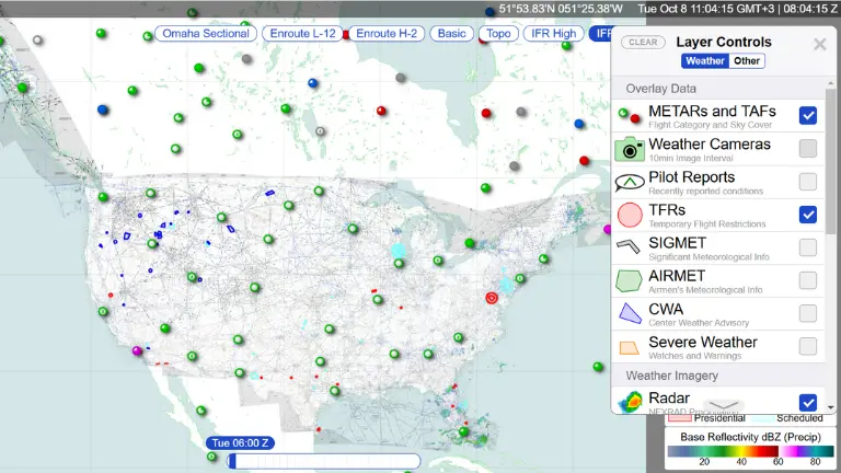
Weather constitutes one of the most influential variables in aviation. As a pilot, you need to know the current and forecasted weather at the departure airport, alternates, and destination, in addition to your planned flight route.
Similar to NOTAMS, you’re able to check the weather in multiple ways. In the US, you can view weather data online at 1800wxbrief.com or aviationweather.gov. You may also call 1800-WX-BRIEF to access local and en route weather.
Quite a few apps, like ForeFlight or Avia Weather, also provide METAR and TAF information while airlines prepare these reports and forecasts for pilots ahead of flights.
Known ATC Delays
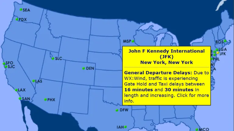
Delays aren’t rare in the aviation industry. Known ATC delays are already reported or currently happening delays, typically caused by weather, congested airspace, and late arrivals.
Knowing current delays at the destination or en route allows you to plan accordingly. For example, you may postpone the departure time or request more fuel.
You can view known ATC delays on the FAA Flight Delay Information website.
Runway Lengths
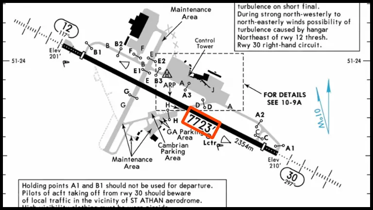
This part is self-explanatory. You need to know the departure, arrival, and alternate airports’ runway lengths. Moreover, it’s prudent to be familiar with the airport landing, takeoff, and taxi procedures.
You can find this information in the airport diagram section of the aeronautical charts (often provided by Jeppesen). You can also check the Chart Supplements (formerly Airport/Facility Directory).
Alternates Available
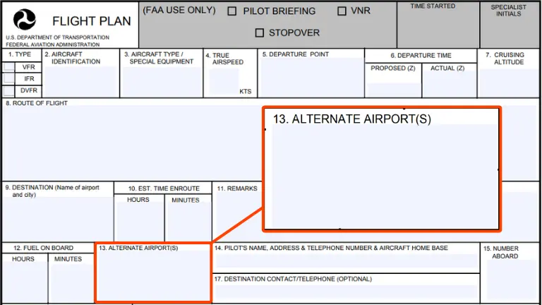
An alternate airport is simply a backup airport where you can land if you can’t land at your destination.
VFR flights don’t require alternate airports, but it’s wise to have one in mind. For IFR flights, though, having at least one alternate destination airport is commonplace.
There’s even a rule to determine whether you need to select and file an alternate airport.
It’s called the 1-2-3 rule (based on 14 CFR 91.169), which states that you need an alternate if the weather forecast at your destination isn’t:
- Within 1 hour before and 1 hour after your Estimated Time of Arrival (ETA)
- Have a ceiling of at least 2,000 feet above the airport elevation
- and visibility of at least 3 statute miles
Fuel Requirements

You should always plan to land at your destination with higher fuel reserves than the regulatory minimums. The fuel requirements, which signify the fuel you’d have beyond your destination or alternate, are outlined in the Federal Aviation Regulations:
- For airplanes flying under VFR: enough fuel for 30 minutes during the day and 45 minutes at night (14 CFR 91.151)
- For IFR flights: fuels reserves for 45 minutes beyond the alternate airport, except if your destination has an instrument approach procedure and weather minimums allow for such an approach (14 CFR 91.167)
But these are minimums, it’s a good idea to have a higher personal minimum. Say one hour.
As fuel consumption varies by flight stage (e.g., taxi, climb, cruise), pilots calculate the total fuel required using different performance charts. Airline pilots have these calculations available in the flight plan, which is prepared by a dispatcher.
Takeoff and Landing Distances

You must calculate takeoff and landing distances at your departure, arrival, and alternate airports before takeoff. The Pilot’s Operating Handbook (POH) and the Airplane Flight Manual (AFM) both have performance charts, or graphs, to calculate these distances.
Aviation regulations also set requirements and minimums for takeoff and landing distances. You can check 14 CFR 25.113 (takeoff) and 14 CFR 25.125 (landing) to get an idea.
Airline pilots often use a performance calculator or app where they can enter relevant data (e.g., aircraft weight, outside air temperature, etc.) to get the takeoff or landing distance.
Is NWKRAFT the Only Preflight Action Acronym?
Nope. Two other acronyms serve the same purpose.
The FAA recommends the acronym WEALTH, as in you need a “wealth” of information before flying. The mnemonic stands for:
- Weather
- Expected Performance
- Alternates
- Length of Runways
- Traffic delays and terrain avoidance
- How much fuel is required
FATWORK is yet another, funny-sounding NWKRAFT alternative. Maybe as in it’s “fat work” planning a flight. FATWORK stands for:
- Fuel
- Alternates
- Takeoff (departure procedure)
- Weather
- Other pertinent information
- Runway lengths
- Known ATC delays
See? Aviation acronyms can be fun.
Final Thoughts
Mnemonics are helpful memory aids in both general and commercial aviation. As a pilot, you have so much to keep track of, and pilot acronyms like NWKRAFT make your job a little easier.
But NWKRAFT includes the bare minimum. You should always aim to be familiar with ALL the available information for a particular flight, such as the departure procedures, weight and balance data, and takeoff speeds.
